loader

JSC Severneftegaz has 3 licenses for geological exploration on the shelf of the Barents Sea

Recoverable resources in these license areas are estimated at 495 million tons o.e.


Details

All license areas are located 180 km from the large port of Murmansk

The water area is ice-free all year round, which makes it possible to create favorable conditions for the exploitation


Details

About Us

Joint Stock Company "Severnaya Neftegazovaya Kompaniya" (JSC "Severneftegaz"), was founded in October 2001, has more than ten years of experience in working on the shelf of the northern seas and, in accordance with Russian law, has the right, along with the state-owned PJSC Rosneft and PJSC Gazprom, to act as a subject of law to obtain licenses for geological exploration, exploration and production on the continental shelf and to carry out related work. The main subject of the Company's activity is geological exploration of subsoil areas for the purpose of prospecting and appraisal of hydrocarbon deposits on the shelf of the Barents Sea.


JSC "Severneftegaz" has 3 licenses for geological exploration of three sections of the Kola-Kaninskaya monocline on the shelf of the Barents Sea to the north of the Kola Peninsula for the purpose of prospecting and evaluating hydrocarbons. The licensed areas of AO Severneftegaz Kolsky-1,2,3 are located in the southeastern part of the Barents Sea, 30 km from the coast of the Kola Peninsula and 110 miles from the port of Murmansk. The total area of ​​the plots is 4,550 sq. Km. The sea depth is about 200 m. This water area is located in the non-freezing part of the sea.

Shareholders

Distribution of JSC "Severneftegaz" capital at 31.12.2021

Number of holders of ordinary shares Number of shares Percentage of total shares
Russian legal entities 1 100 000 100%
TOTAL 100 000 100%

Benefit #1

The company is registered in Russia

Benefit #2

Transparent ownership history

Benefit #3

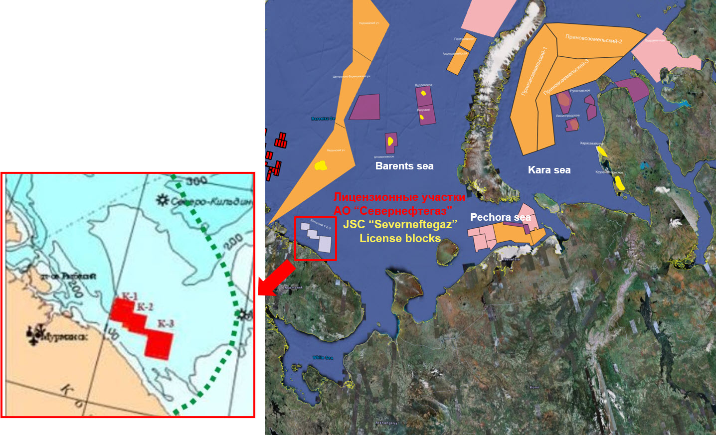
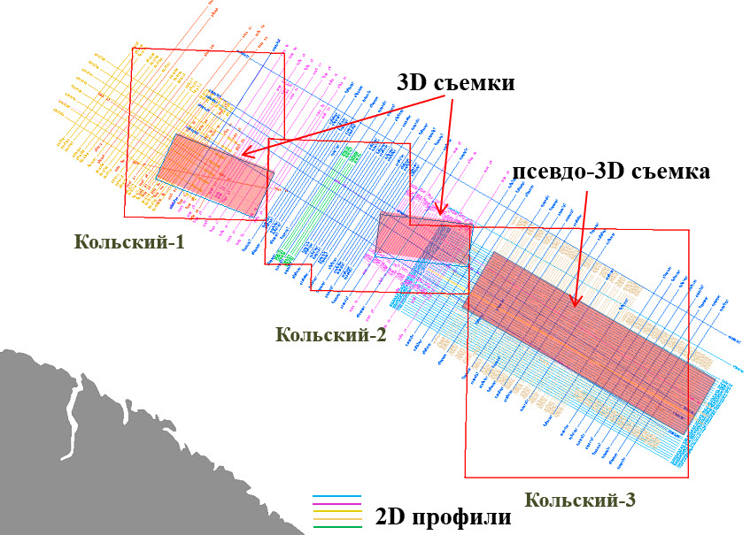
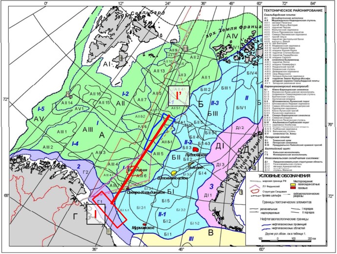
The entire range of preparatory work for the drilling of priority wells was carried out at the licensed areas

Benefit #4

License agreements extended until 2027

Benefit #5

Flexible terms of the deal for a potential investor

Benefit #6

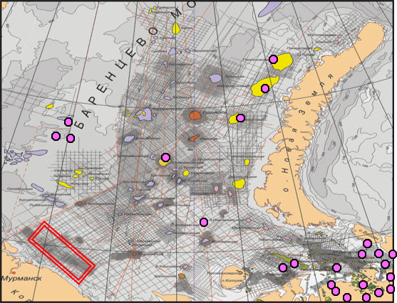
According to foreign experts, the sites are of commercial value, there is a possibility of discovering

CEO

JSC "Severneftegaz"

Mission

JSC Severneftegaz has been carrying out offshore operations at the Kolsky-1,2,3 sections since 2005. Over the past period, more than 10,500 linear kilometers have been processed. seismic profiles using 2D and 400 sq. km according to the 3D method. As a result of seismic studies in the license areas, 9 reef traps and 2 structural traps were identified. Geologically, the sites are confined to the Kola-Kaninskaya monocline. Target horizons - Permian age. The depth of the target horizons is about 2000 m.

Ecology

When carrying out work on the study and development of the resources of the continental shelf of the Barents Sea, JSC Severneftegaz has been paying due attention to environmental protection and ecological safety since its inception. In the Arctic, which is characterized by increased sensitivity to any pollution due to extremely slow self-cleaning of the environment, this circumstance is of particular importance.

At the licensed areas of AO Severneftegaz, FGUP VNIIOkeangeologiya has carried out marine ecological and geochemical studies in order to monitor the natural environment. Their main task was to identify background and anomalous characteristics of pollutant complexes in surface bottom sediments and water column in the contours of promising structures and at the design points of the first deep exploration wells prior to deep exploration drilling for oil and gas. The results obtained make it possible to assess the current ecological state of individual components of the marine environment and the ecosystem as a whole and, first of all, the natural level of pollution of the marine environment, and will be the initial basis for environmental monitoring in the process of geological exploration and production for oil and gas.

State of geological exploration

Severneftegaz has licenses for prospecting and exploration of hydrocarbons in 3 areas of the Barents Sea shelf: Kolsky-1 (1150 sq. Km), Kolsky-2 (1100 sq. Km) and Kolsky-3 (2300 sq. Km.). The license areas are located near the Kola Peninsula, at a distance of 30-70 km north of the coast, and about 100-150 km from the city of Murmansk, a large seaport connected to central Europe by rail and air transport. The sea depth within the license areas ranges from 105 to 255 m. Thanks to the warm Gulf Stream coming from the Atlantic, the region is navigable throughout the year.

The license areas are located on the Kola-Kaninskaya monocline (KKM) in the Barents Sea basin - in the southern part of the Barents Sea oil and gas province. In the east, the KKM adjoins the Timan-Pechora oil and gas province with numerous occurrences of hydrocarbons at sea and on land in Paleozoic sediments.

In the northwest, the KKM is bordered by the Finnmark platform (Norwegian shelf), whose hydrocarbon potential is associated with Permian and Triassic deposits. The prospective HC potential of the KKM is also associated with Paleozoic sediments.

At the end of the 90s of the last century in the area of ​​the Kola-Kaninskaya monocline, seismic surveys of the CDP MOV of varying degrees of detail and scale were carried out. In 2005, within the framework of fulfilling licensing obligations, 3D seismic works with a volume of 200 sq. Km were performed at the Kolsky-1 and Kolsky-2 blocks. In the same year, a detailed 2D seismic survey was carried out at the Kolsky-3 site in the amount of 2000 linear meters. km. and digital processing of seismic data using pseudo-3D technologies - 1150 sq. km.

Until 2005, more than 8500 km of 2D seismic surveys of various details were carried out on the Kola monocline. Drilling directly on the sites (and on the monocline in general) was not carried out; the nearest wells that penetrated the Triassic: Severo-Kildinskaya (gas), Murmanskaya; Peschanoozerskaya (oil); Izhimka-Tarskaya (oil); wells in the Norwegian part of the water area.

The nearest wells, which were exposed by the Paleozoic, including the productive one, located on the offshore continuation of the Timan-Pechora province and in the Norwegian part of the water area. According to the results of seismic exploration at the Kola-Kaninskaya monocline, numerous anomalies of the "reef" type in the Paleozoic and anomalies of the "bright spot" type in the Mesozoic were revealed.

Geological setting

Tectonically, the licenses are located in the central part of the Kola-Kaninskaya monocline, which is part of the Barents Platform. In the west, the Kola-Kanin monocline continues into the Norwegian sector of the Barents Sea, where it is called the Finnmark platform. and in the northeast it passes into the South Barents depression. In the southeast, the monocline is bordered by the structures of the Pechora Plate.

The sites belong to the Kola-Kaninskaya monocline, bounded from the southwest by the Kola block of the Baltic Shield, from the southeast by the uplift of the Kanin Peninsula.

The sedimentary cover is represented by sediments from the Riphean-Vendian - in deep interblock troughs - to the overlying carbonate and terrigenous strata dating from the Cambrian to the Jurassic-Cretaceous. At the same time, monoclinal layers of Devonian-Carboniferous, Permian and Mesozoic rocks emerge directly on the license area on the seabed or under thin Quaternary sediments.

In the Late Paleozoic, beginning with the Late Devonian, the Kola-Kaninskaya monocline was part of a vast carbonate platform extending from the FinnMark platform along the northern edge of the continent up to Novaya Zemlya. Thus, the Kola-Kaninskaya monocline experienced a single development with the Finnmark platform and the structures of the Pechora plate, which determined a similar lithological-facies composition of the Upper Paleozoic deposits, the genetic type of structures and, ultimately, the prospects for oil and gas potential.

The Finnmark platform and the Kola-Kaninskaya monocline belong to different oil and gas systems. The first belongs to the Bjarmsland-North Cape system, with Upper Permian, Triassic and Jurassic oil and gas source rocks, hydrocarbon migration from the Hammerfest and North Cape troughs upsection towards Finnmark and Bjarmeland. The second refers to the South Barents oil and gas system with Devonian, Carboniferous, Permian and Triassic psftgasomatsrip sediments, hydrocarbon migration from the sub-slope zones of the South Barents depression.

By the component composition of oil and gas systems, tp In terms of the stratigraphic range, lithological-facies composition, and formation conditions of the psftsmatsrinsky rocks, a similarity is established between the Kola-Kaninskaya monocline and individual regions of the Timan-Pechora plate, which makes it possible to use hydrocarbon deposits as geological analogs for determining the estimated parameters of promising traps of the Kola-Kaninskaya monocline.

It can be seen from the section that the platform cover overlying the Precambrian basement includes strata of the undivided Paleozoic (presumably from the Cambrian or Ordovician to the Lower-Middle Devonian), overlying the oil and gas promising deposits of the Upper Devonian-Permian and the entire Mesozoic. The red rectangle shows the location of the license area.

On the section, along with the structural features of the Triassic deposits, one can see the presence of a local trough filled with Devonian and Carboniferous deposits. This trough may contain oil and gas source Domanic facies and, along with the common basin of the South Barents Basin, serves as a local oil and gas generation basin (local HC “kitchen”) supplying migration HCs to traps.

The stratification of seismic sections, the forecast of the formation and lithological composition of the section and the conditions of its formation are based on the data of the analysis of wells in the Russian part of the Barents Sea and the Timan-Pechora province.

Correlation of the Paleozoic and Mesozoic sections, including the productive deposits of the southeastern part of the Barents Sea on the transit (land-sea) line of wells of the Varandey-Adzvinskaya zone of the Timan-Pechora plate

Correlation of the Paleozoic and Mesozoic sections, including the productive deposits of the southeastern part of the Barents Sea on the transit (land-sea) line of wells of the Varandey-Adzvinskaya zone of the Timan-Pechora plate


The main source of migratory hydrocarbons for filling the Paleozoic traps of the Kola-Kaninskaya monocline is, most likely, the South Barents depression conjugated with it, and in its structure - the Murmansk-North-Kildin step directly adjacent to the monocline. Within the latter, the roof of the main oil source complex of the region - the Upper Devonian strata containing the Domanik suite and its analogues - lies at depths from 3 to 7-8 km.

Analogous deposits from the Timan-Pechroskaya oil and gas field (for all promising intervals presented in the KKM section) and the North Caspian basin (for the Upper-Lower Devonian and Carboniferous deposits).

Directly in the Barents Sea in 1995-2001 two groups of researchers - VNIGRI under the leadership of V.K. Shimansky and IGiRGI under the leadership of L.I. Lebedev, the geochemical characteristics of the deposits in the Triassic section of Kolguev Island (Peschanoozerskoe and Tarkskoe), located on the offshore margin of the Timan-Pechora plate facing the South Barents depression, and dispersed sedimentary matter from the sedimentary deposits of the South Barents depression were investigated.

The research results showed that the source of oil generation for the indicated fields could be located in the adjacent zone of the South Barents depression, in particular, in the area of ​​the Kurentsovskaya stage, which belongs to the upper part of the southeastern slope of this depression. The main source of migratory hydrocarbons for filling the Paleozoic traps of the Kola-Kaninskaya monocline is, most likely, the South Barents depression conjugated with it, and in its structure - the Murmansk-North-Kildin step directly adjacent to the monocline. Within the latter, the roof of the main oil source complex of the region - the Upper Devonian strata containing the Domanik suite and its analogues - lies at depths from 3 to 7-8 km.

Oil & Gas potential

According to the results of geological and geophysical studies, the KKM belongs to the East Barents province, and in its composition - to the South Barents oil and gas region or is separated into a separate region. By analogy with the neighboring regions of this province and the provinces adjacent to the west and east (West Barents and Timan-Pechora), Triassic, Permian-Carboniferous and Devonian deposits are considered as the main oil and gas complexes.

The main oil and gas fields of the Timan-Pechora oil and gas province are associated with Paleozoic sediments, mainly Upper-Lower Carboniferous and Upper Permian carbonate complexes

Model of the formation of oil and gas content of the Kola-Kaninskaya monocline, southwestern side of the South Barents depression

The nature of the display on the seismic time section of the Upper Permian reef structures in individual license areas and their 3D morphology, as well as the Vladimirskaya and Vostochnaya anticlinal structures located, respectively, in the Kolsky-1 and Kolsky-3 areas.

The nature of the display on the seismic time section of the Upper Permian reef structures in individual license areas and their 3D morphology, as well as the Vladimirskaya and Vostochnaya anticlinal structures located, respectively, in the Kolsky-1 and Kolsky-3 areas.

The nature of the display on the seismic time section of the Upper Permian reef structures in individual license areas and their 3D morphology, as well as the Vladimirskaya and Vostochnaya anticlinal structures located, respectively, in the Kolsky-1 and Kolsky-3 areas.

Resources estimation

The main potential of the Kola-Kaninskaya monocline is associated with organogenic edifices (anomalies of the "reef" type) in the Carboniferous - Permian sediments. In the aquatorial part of the Timan-Pechora province, the main reserves of all deposits are confined to similar structures in the coal-lower Permian part of the section. In the Norwegian sector of the Barents Sea, oil deposits have been discovered in Upper Permian organogenic structures in a number of areas.

Within the license areas, there are 15 large organogenic structures with a total area of more than 500 sq. km.

Upper Permian reef with spiculite on a 3D cube (Kolsky-1 area)

The second most important promising interval is the Terrigenous Triassic. In the Triassic sediments, commercial hydrocarbon deposits were discovered in the nearest areas of the Russian sector of the Barents Sea, on the Finnmark platform and in the Pechora Sea.

Oil resources were estimated using the deterministic volumetric method. To determine the area and volume of productivity, structural maps were used for reflecting horizons III3 (D3), I-II (C2 + 3), IIv (C1v), Ia (P1a + s) and isopach maps of reef carbonate deposits of the Upper Permian and Upper Permian spiculites.

Strategy and plans

In accordance with its licensing obligations, JSC Severneftegaz has completed a large-scale complex of marine geological and geophysical, geochemical, engineering and geological, geoecological and research works at the Kolsky-1, Kolsky-2 and Kolsky-3 areas and planned to:
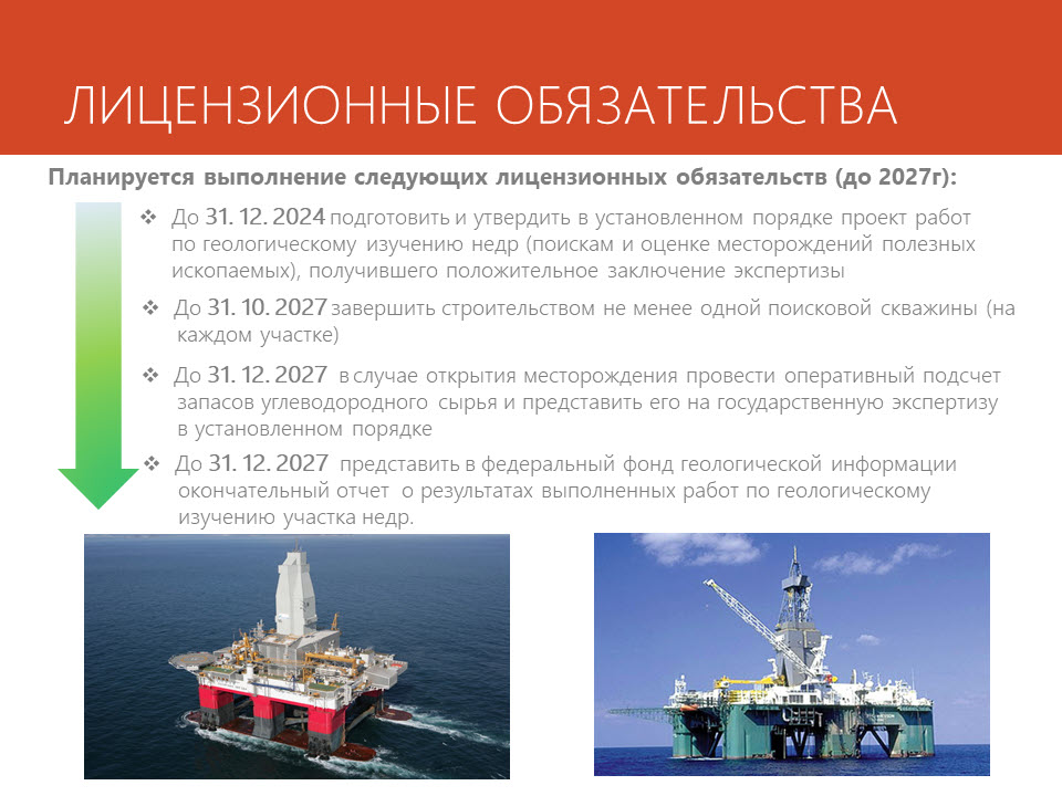
- Until 2024/12/31 perform the exploration and appraisal plan
- Until 2027/10/31 one well in each license area to be drilled
- Until 2027/12/31 to present to the federal fund of geological information the final report on the results of geological studies of the subsoil area
- Until 2027/12/31 in the case of the oil field discovery make reserve calculation hydrocarbons and submit it to the State Balance in the established order

Main tasks for the period 2022 - 2027

Contacts

Company office

Company address

Moscow
st. Zoologicheskaya, 4

Mail and phones

sng@severneftegaz.ru
Tel.: 8 (495) 721-91-31

Office hours

Mon-Fri: 9.00-18.00